
Being the largest country in the world, Russia is also rich in rivers, many of which are amazingly powerful. Famous rivers in Russia are not only the most important waterways and energy sources, but also picturesque places that attract tourists from all over the world.
MỤC LỤC
Interesting facts about the Volga River
The Volga is a mighty river flowing through Russia and partly Kazakhstan. As one of the largest rivers in the world, the Volga River rolls its waters leisurely towards the Caspian Sea. It is an extremely important transport artery for Russian shipping, and its banks were admired by holidaymakers who preferred to spend their holidays on a Volga river cruise by motorboat back in Soviet times.
The history of the Volga River dates back to the ancient world. It was established at least in the 5th century BC.
In the writings of Herodotus, the Volga River is mentioned for the first time, and Herodotus describes the Russian river in the battle of the Persian king Darius against the Styrian tribe. Herodotus called the Volga River the River of Paddles.
The Volga River is not only a navigable river, but also an extremely important source of electricity: hydroelectric power plants on the Volga River provide electricity to all the neighbouring cities. It used to usually reach Tver, but now the hydroelectric power station on the river no longer allows it.
About 40 per cent of Russia’s population lives along the banks of the Volga, and half of the country’s farmers are engaged in agricultural production along the river.
The construction of a reservoir on the Volga reduced its length by one hundred and sixty kilometres.
The Volga River has always played an exceptional and central role in history. In a sense, it is the root and core of people and an ideal. In oral and written works, the Volga is almost always alive.
Every day the Volga River pours about two hundred and fifty cubic kilometres of water into the Caspian Sea. Despite this, the sea level is still steadily falling.
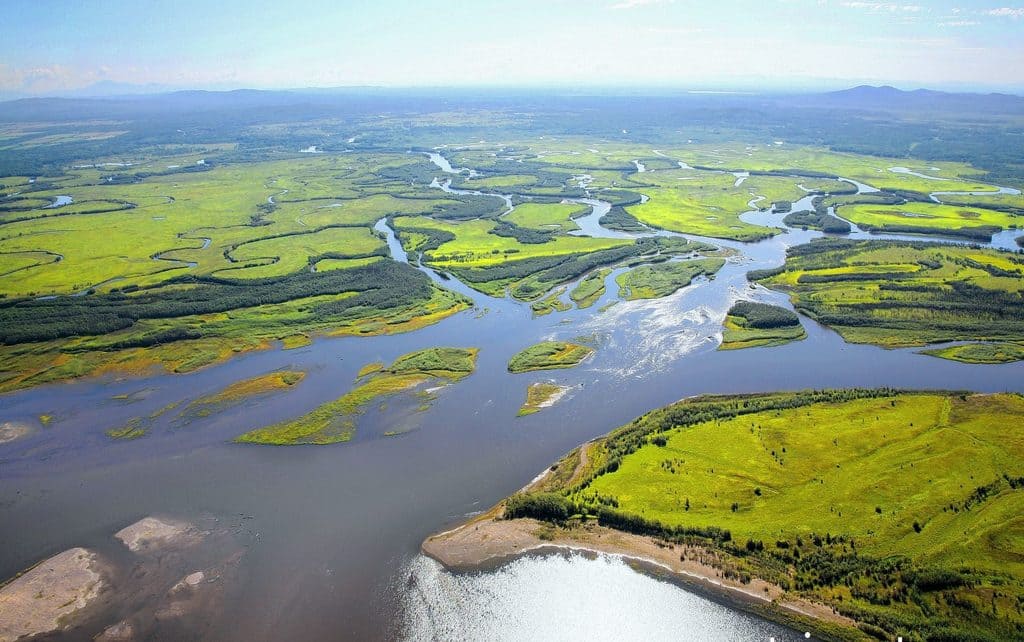
The Volga estuary is the largest in Europe and the only place in Russia where pelicans and flamingos live.
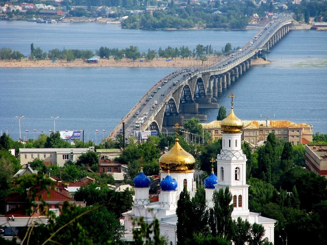
Another interesting fact about the Volga River is that the oldest of the operating railway bridges crosses the Volga River – the Alexandrovsky Bridge was built in 1880.
Ancient writers of the first century AD called the Volga Ra or Rav (both of Iranian origin). In the Middle Ages, the Volga, Kama and Belaya rivers were called Volga.
Many historians believe that the Volga River was the birthplace of the Soviet Republic. Of course, there was a revolution in St. Petersburg, but the new power on the Volga got stronger and won.
The city at the turn of the Volga River (now Volgograd) witnessed the Battle of Stalingrad, which, was the bloodiest battle in human history.
The Caspian Sea is sometimes classified as an undrained lake, where the water is not salty but only brackish. This is largely an advantage of the Volga River: the river brings too much fresh water into it, which greatly reduces the size of this huge body of water.
Interesting facts about the Don River
For centuries and millennia, the Don River has served as a natural barrier that limited the spread of different peoples who lived on its banks. In our time, however, the importance of the Don has not diminished, it is just that now it is used as a transport artery and a source of water for millions of people.
The average speed of the Don River is only 3 kilometres per hour. That’s why it was nicknamed ‘quiet’ back in the olden days.
There are other rivers in the world with the same name, and two of them are in the UK.
In the waters of the Don River there are 67 species of fish, and some of them are included in the Red Book of Russia.
The Don River is mentioned in the ‘Tale of Igor’s Campaign’. This is the first written mention of it discovered by historians.
During the time of Peter the Great, the Russian navy grew rapidly and became a formidable force that successfully confronted the Ottoman Empire. Most of the trees for building ships were cut on the banks of the Don River (see 25 interesting facts about Peter the Great).
The average slope of the Don River does not exceed 0.1 degrees. The vertical distance from its source to its mouth is only 180 metres.
The area of the Don delta is approximately equal to the area of Omsk. At the same time, the area of its entire catchment area exceeds 440,000 square kilometres, which is larger than the area of many countries.
There are eight large islands on this river.
On the banks of the Don there are two dozen cities, of which two are included in the list of ‘million-strong’. These are Rostov-on-Don and Voronezh.
The Don is navigable for 75% of its length.
Floods on the Don River can be very destructive. The water level in spring can rise by 10-12 metres in some places, or even more.
The Don receives about 70% of its water through spring snowmelt (see 19 interesting facts about snow).
The Don River has many tributaries, and five of them are called ‘Donets’.
Five or six centuries ago, Russia traded with Byzantium, using this very river as the main trade route.
Judging by archaeological finds like stone axes, tens of thousands of years ago primitive people lived on the banks of the Don.
The Sea of Azov, into which the Don flows, is much younger than this river. When the Sea of Azov did not yet exist, it flowed into another sea – the Black Sea.
This river was well known to the ancient Greeks. About 2 millennia ago, the city of Tanais, built by them, stood at its mouth.
The word ‘Don’ in the language of the Scythians and Sarmatians meant simply ‘river’.
The Don River is only the 66th longest river in the world, but the 5th among all the rivers in Europe. Its length reaches 1870 kilometres.
A few centuries ago, there were wild horses on its banks, but due to the active settlement of people around the Don, these animals gradually disappeared here.
Interesting facts about the Amur River
The Amur River rolls its mighty waters for several thousand kilometres, dividing the territories of Russia and China. This river has always had the most important meaning for the peoples inhabiting the surrounding land, but it is not only beautiful, but also sometimes dangerous – the spring flood of the Amur can sweep away everything that was built on its banks.
Both Russians and Chinese are equally proud of the Amur, considering it ‘their’ river. The Chinese call the Amur ‘Heihe’, which means ‘Black River’ in Chinese.
The name ‘Amur’ was derived from the local vernacular words ‘amar’ and ‘damur’, meaning ‘big’ and ‘river’ respectively. So Amur is a ‘big river’. You can’t argue with that, although, for example, the Lena River is still bigger (see interesting facts about the Lena River).
The area of the Amur River basin is almost 2 million square kilometres. This is an impressive figure. By this parameter, the Amur ranks tenth in the world (see interesting facts about rivers).
The Amur Bridge crossing the river is depicted on a five thousand ruble banknote.
There are quite a few islands on the Amur, the largest of which is the Bolshoi Ussuriysky Island located near Khabarovsk.
The waters of the Amur River are home to such fish as salmon and sturgeon (see interesting facts about fish).
In general, the diversity of life in the Amur River is amazing – there are more than 140 different species of fish, which is more than in any other Russian river.
The Amur riverbed is slowly but surely moving, washing a new path for itself.
Three quarters of the water that replenishes the Amur comes into the river thanks to monsoon rains, not glaciers as is the case with many other rivers in Russia.
The mouth of the Amur River spews almost 13,000 cubic metres of water into the sea every second.
Interesting facts about the Kama River
People have lived around the Kama River for centuries, and nowadays its banks are also quite densely populated. This large river, which is on the list of the longest in the world, has for centuries served both as a source of food and as a transport route. Its waters are now, however, noticeably polluted in some sections, but in recent years a number of efforts have been made to clean them up.

One of the local natural attractions is the unique gypsum mountains. You can see them not far from the city of Perm, they rise on the very bank.
During its course, the Kama River changes direction several times. If you look at a map, you will find that its bed is shaped like a giant question mark.
The construction of the Kuibyshev reservoir has reduced the length of the Kama River by 225 kilometres. The river used to be 2030 kilometres long, but now it is only 1805 kilometres long. At the same time, the straight line distance from the source to the mouth does not exceed 450 kilometres, as the Kama riverbed is very sinuous.
Officially, the Kama is considered to flow into the Volga. However, a number of scientists suggest that it is the Volga that flows into the Kama, as the Volga is inferior to it in a number of ways.
In a year, the Kama replenishes the Volga with an average of 117 cubic kilometres of water.
It ranks third in fullness among all Russian tributary rivers. The Angara and Aldan take the first two places (see 22 interesting facts about rivers).
Three hydroelectric power plants (hydroelectric power stations) have been built on the Kama River, providing electricity to millions of people.
The Kama is one of the first in the world in terms of the number of tributaries flowing into it, of which there are almost 75 thousand. However, only 5.5% of them are more than 10 kilometres long.
Geologists have established that once upon a time the Kama flowed into the Caspian Sea, but after the last ice age its course changed its direction (see 15 interesting facts about the Caspian Sea).
The Kama is one of the ten longest European rivers, ranking seventh.
Floods on the Kama can be very destructive. The water can rise 6-8 metres above the normal level, and the river overflows wide, sweeping away everything around it.
In Russia, quite a few rivers in different regions are called ‘Kama’, but mostly they are all rather small rivulets. In the Republic of Tatarstan, the Kama is called ‘Chulman’ and the Udmurts use the name ‘Kam’.
99.8 per cent of this river flows through Russia. The remaining 0.2 per cent goes to Kazakhstan.
The area of its catchment area is more than 0.5 million square kilometres.
Interesting facts about the Lena River
The Lena River is a great river, and many peoples living in its vicinity have many myths and legends associated with it. The mighty Lena River originates on the spurs of the Baikal Range and flows into the Laptev Sea in the north. Nature lovers are not left indifferent and the famous ‘Lena Pillars’ – incredibly beautiful rocky shores, representing a truly unique natural formation.

The Lena is the fullest river in Russia, the third longest. Its length exceeds 4400 kilometres, which puts it on the tenth place in the list of the longest rivers in the world.
During spring floods, the level of the Lena rises by ten to fifteen metres.
The banks of the Lena are practically uninhabited for this very reason – during the overflow it sweeps away all the neighbouring buildings.
The name of the river means ‘Big River’ in the language of those living in the Lena’s vicinity.
From its source to its mouth, the Lena River flows only through the territory of Russia.
Of all the rivers in Eastern Siberia, the Lena is the largest. Most of its banks are surrounded by impenetrable taiga.
It is also the only river in the world whose bed is completely located in permafrost areas.
The city of Olyokminsk has a monument to the river, erected on its embankment.


